A towering 400-foot-tall sandstone pillar, located three miles west of the visitor center off Highway 24 and accessible via a short hiking trail.
The trailhead to Hickman Bridge gives you three hiking options, depending on how much time and energy you have.
LENGTH:
The 1.8-mile round-trip walk to Hickman Bridge takes about 1.5 hours, the 4.6-mile round-trip hike to the Rim Overlook (on the Navajo Knobs trail) takes three to four hours, and the 9.4-mile round-trip hike to the Navajo Knobs takes six to eight hours.
TRAIL DETAILS:
The trail to all three of these destinations starts along the Fremont River and then heads down into a wash with a great view of the park’s namesake Capitol Dome.
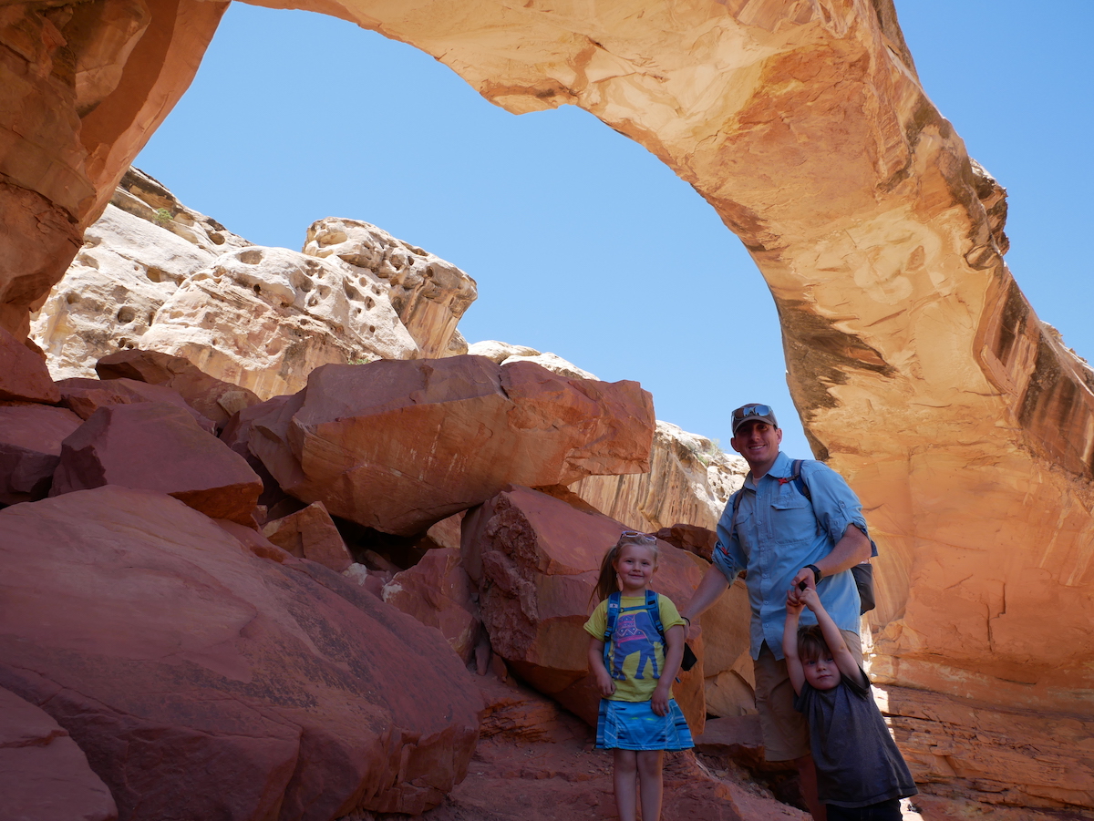
After 0.2 miles you’ll reach the Hickman Bridge/Navajo Knobs junction. To see Hickman Bridge, a natural sandstone arch, go left. The trail gradually climbs 400 feet through a landscape defined by tall tan rock walls, junipers, cottonwoods, and ancient sand dunes. There are some artifacts of the Fremont people, like the remains of a pit house and of a granary, that you can check out along the way. The trail then comes to a junction, and you can go in either direction to circle beneath the bridge. The Hickman Bridge, which was shaped by flowing water, stands an impressive 125 feet high and is 133 feet long.
LOCATION
Right off of State Route 24 – 3 miles west of the Visitor Center.
GPS COORDINATES
38.288780, -111.227650
GEAR CLOTHING WE NEEDED
With climbing up and down on sandstone it’s best to have good grip hiking shoes or sandals. Here are our favorites.
During those warm summer months just make sure to bring sun screen, a hat, and always extra water. We always like our Days packs with our hydration bladder. Here are a few of our favorites.
CAPITOL REEF GALLERY
BACK TO:
Click here to return to our Complete Guide to Capitol Reef National Park
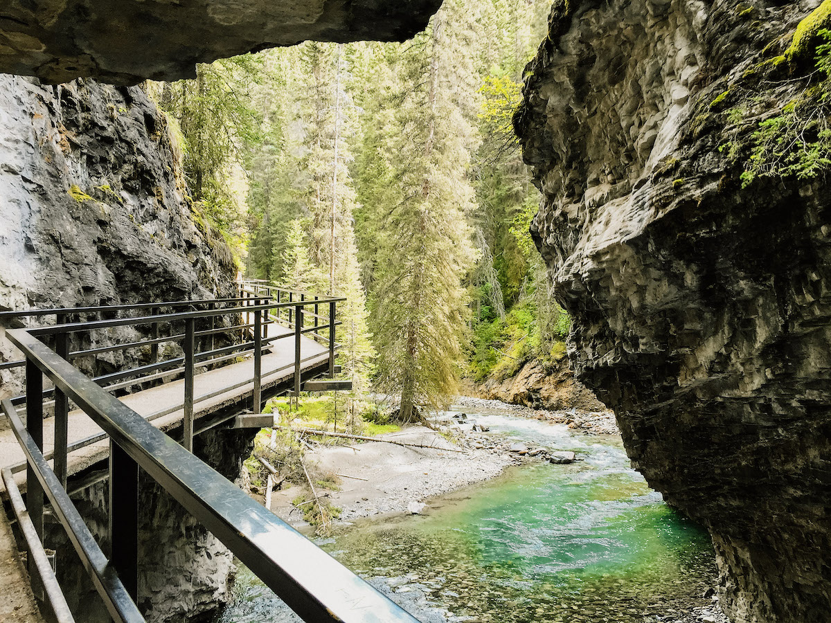
Take a catwalk with the steep walls of the canyon jutting high above you and the deep blue pools of the creek far below.
Carved steeply into the limestone bedrock by thousands of years of water erosion, the dramatic Johnston Canyon is a must-visit natural attraction in Banff National Park. Overhanging canyon walls, waterfalls, the deep pools of Johnston Creek, and lush forest are sure to leave a memorable impression. And it can all be experienced via an easy hike along smooth trails and catwalks, making it ideal for families and people of all ages.
It’s amazing how much varied scenery you see over the course of the very short 1.7 mile hike.
We hope you enjoy it as much as we did!
LENGTH:
3.5 MILE ROUNDTRIP OR TO THE INK POTS FOR AN ADDITIONAL 3.6 MILES
Time to reach lower falls 30 minutes, 1.1 km one way, elevation gain of 30 meters.
Time to reach upper falls, one hour , 2.6 km’s one way, elevation gain of 120 meters.
Return trip going to both lower and upper falls allow 2 to 2.5 hours.
TRAIL DETAILS:
The trail to the lower falls covers minimal elevation as it works its way through the forest. It then takes you over catwalks alongside Johnston creek and up into the canyon above the rushing waters below. As the trail approaches the lower falls the first site that comes into view is a deep pool that has been created by the plunging water. A bridge crossing the creek serves as an excellent viewing spot, but there is another platform that sits within meters of the falls. To get to it you have to go through a tunnel in the canyon bedrock. Don’t be surprised if you and your camera get misted with water.
The trail to the upper falls covers more elevation as it climbs its through the forest and out of the lower canyon. It works its way back towards the creek and offers several scenic viewpoints, like this small set of cascading waterfalls. There are two viewing areas. The first is accessed by a catwalk that leads to a viewing platform looking across to the bottom of the falls. The other viewing area can be reached by taking a steeper trail to a platform overhanging the gorge. It looks across to the top of the falls that drop a dramatic 40 meters.
The Trail To The Ink Pots Beyond The Upper Falls
The Ink Pots consist of several pools made up of greenish coloured mineral springs that bubble to the surface. If you have time, carry on to the Ink Pots to leave the crowds behind you and get some solitude. From the upper falls the trail is a moderate climb out of the canyon for 3 km’s through the forest. It opens up to a meadow where the Ink Pots sit. The hike from the upper falls to the Ink Pots takes approximately one hour.
The Ink Pots are also accessible via Moose Meadows. This route completely bypasses the Johnston Canyon Trails. The trail head is located 1.4 km’s west of Johnston Canyon on the Bow Valley Parkway. It is 5.9 km’s one with an elevation gain of 215 meters. Allow 4 hours round trip.
TIPS FOR HIKING:
The trail has a lot of shaded areas, it can get cool even in summer months, dress in layers to adjust to the temperature as needed.
Pack drinking water and a snack
LOCATION
Johnston Canyon is located 25 kilometres (around 30 minutes’ drive) from the town of Banff and 33 kilometres from Lake Louise on the Bow Valley Highway.
The hiking trail starts at the northern end of the parking lot, right behind Johnston Canyon Lodge.
GPS COORDINATES
51.245748, -115.839925
AMENITIES:
There are washrooms at the parking lot, and a gift shop and restaurant open during summer at the Johnston Canyon Resort.
We promised the kids ice cream or a popsickle after the hike, and turns out they received it at the very end. Their was a cute little gift shop and tiny bar stool restaurant at the end of the hike. It was perfect and unexpected.
The trail to the Lower Falls is stroller and wheelchair accessible – after that there are a few steps.
GEAR CLOTHING WE NEEDED
.
JOHNSON CANYON GALLERY
BACK TO:
Click here to return to our Complete Guide to Banff and Jasper National Park
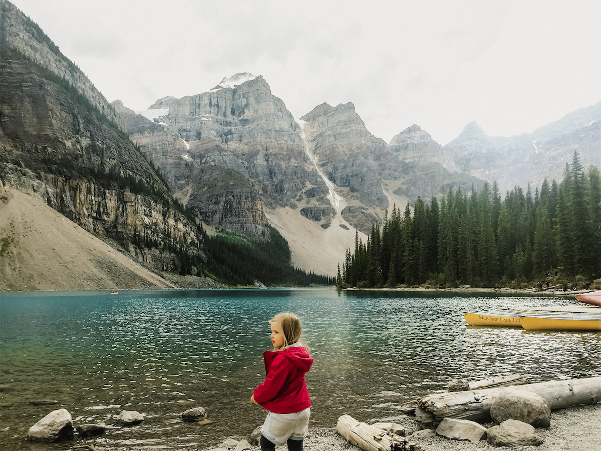
Sit lakeside and absorb the sights and pure mountain air, or explore further by canoeing and hiking. It’s an iconically jaw-dropping place that is sure to leave a lasting impression.
And guess what is the best part about it? No hike required. Park and Walk up – It’s located 8.7 miles outside the Village of Lake Louise. An absolute must see if you’re going to travel along the Ice Field Parkway.
If you ARE looking for a good hike – there are 5 main hikes starting at the lake. (Moraine Lake Lakeshore Trail, Eiffel Lake, Wenkchemna Pass, Larch Valley, and Sentinel Pass) We hope to do those one day! This time we just took in its beauty and took portraits of each other that still hang on our walls today. Memories.
WHEN TO GO:
It is best to go and be there before 10am, because the parking lot feels up. However it is pretty busy during peak season…we went in early September and tried to go twice but the road kept saying closed. Turns out once the parking lot fills up, they don’t allow anyone else up to drive up. It’s best to arrive before 11am or after 5pm for the road to be open easy.
The road to Moraine Lake is closed during the winter due to heavy snowfall and high avalanche risk. Depending on the conditions, the road opens sometime between the third week of May and the first week of June and closes in October after the Canadian Thanksgiving weekend (the second Monday in October).
COST
FREE – Just park and walk
Canoe Rentals: $70/ hour
You’re also not allowed to put in your own canoe here. You do have to rent them at this lake.
THINGS TO DO:
HIKING
There are several hikes around the lake ranging from accessible walks to more strenuous hikes. The Rockpile Trail is an easy and short path with switchbacks along the back of the moraine to the top of the natural dam. The vista from the top is known as the “Twenty Dollar View”, as the scene featured on the back of Canadian twenty dollar bills issued between 1969 and 1979.
Venturing further afield offers solitude from the crowds and a different perspective of the lake and its craggy surrounds. Other trails to explore include Moraine Lake Lakeshore Trail, Eiffel Lake, Wenkchemna Pass, Larch Valley, and Sentinel Pass. In the fall the larches light up in rich shades of yellow, gold, and orange and paint a surreal backdrop for a hike.
During times of high grizzly bear activity there are hiking restrictions in place for many of the trails in the Moraine Lake area. Learn more from the Parks Canada website.
CANOEING
Can I Bring My Own Canoe Or Kayak To Use At Lake Louise?
Yes, you can use your own canoe or kayak at Lake Louise or any of the lakes or rivers within Banff National Park. There’s no public boat launch at Lake Louise. You will have to carry your canoe from the government parking lot area and launch it from shore of the lake. Parks Canada offers more information on paddling in the parks.
LOCATION
It is about a 40 minute drive from Banff to Lake Louise. (80 minutes if you want the scenic route: Bow Valley route 1A.)
From Lake Louise Village, located just off the Trans-Canada Highway (Highway 1), drive uphill on Lake Louise Drive until you see the access road for Moraine Lake on your left. Follow the winding road for 11 kilometres (6.8 miles) to the parking area.
BACK TO:
Click here to return to our Complete Guide to Banff and Jasper National Park
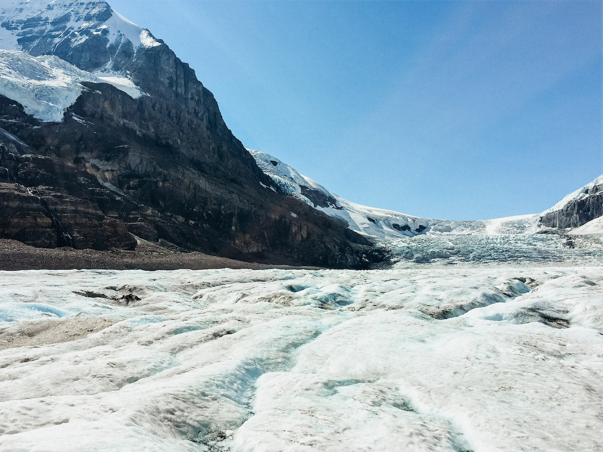
Travel on a massive Ice Explorer to a place where you can walk on, feel and drink from the Athabasca Glacier. Then, take a jaw-dropping walk along the glass-floored Skywalk at the cliff’s edge.
If you’ve seen our other posts then you know that we’re normally not the “tour” tourist. We tend to stay with the free hikes, but Banff and Jasper have these amazing packages that include some pretty cool site seeing that we just couldn’t turn down. Part of our Brewster Package was the COLUMBIA ICE EXPLORER. This giant Ice Explorer takes you up on the Athabasca Glacier! You get to walk on this amazing glacier that you’ve been seeing for miles!
And we of course has to have a snow ball fight!
COST
We purchased the JASPER ULTIMATE EXPLORER COMBO PACKAGE from Brewster Pursuit which included: Maligne Lake Cruise, Ice Glacier Explorer, Sky Walk, and the Banff Gondola.
The Total cost for all 4 excursions was $552 for all 4 of us. Which came to $184 /per adult and $92 per kid, however if you divide that by 4 excursions then it comes to $46 per person per excursion.
Ala Carte Pricing For both Ice Explorer and Skywalk.
Around $100/ adults and $50 per child.
If you are short on time or only want to do the Sky Walk it is $30/ per person. However, for $20 more you might as well do the Glacier. It was the best part! I think $30 is too expensive for just the Skywalk. Just our opinion.
LENGTH
The Columbia Icefield Adventure (including the Columbia Icefield Skywalk) tours departs every 15 to 30 minutes throughout the daily hours of operation.
The adventure lasts approx. 2.5 to 3 hours round-trip.
You’ll learn how glaciers are formed and see other incredible geological features. The Glacier Adventure operates from mid April to mid October inclusive (weather permitting). Tours depart every 15 minutes so that makes timing really nice!
LOCATION
The Glacier Discovery Centre, located on the boundary of Banff and Jasper National Parks, offers interpretive exhibits, interpretive scenic walks, self guided trails, dining room, cafeteria, gift shop and over night accommodation. A perfect midway adventure on the Icefield Parkway!
GLACIER EXPLORER GALLERY
SKY WALK GALLERY
BOOKING DETAILS:
BOOK YOUR EXCURSIONS:
The first thing I did when I got to town was go and purchase my excursion package. You can also do this online ahead of time as well. The pricing is very reasonable.
We recommend doing the Maligne Lake Tour, Columbia Icefield Glacier Discovery that includes the Icefield Skywalk, and the Banff Gondola. They we’re all amazing.
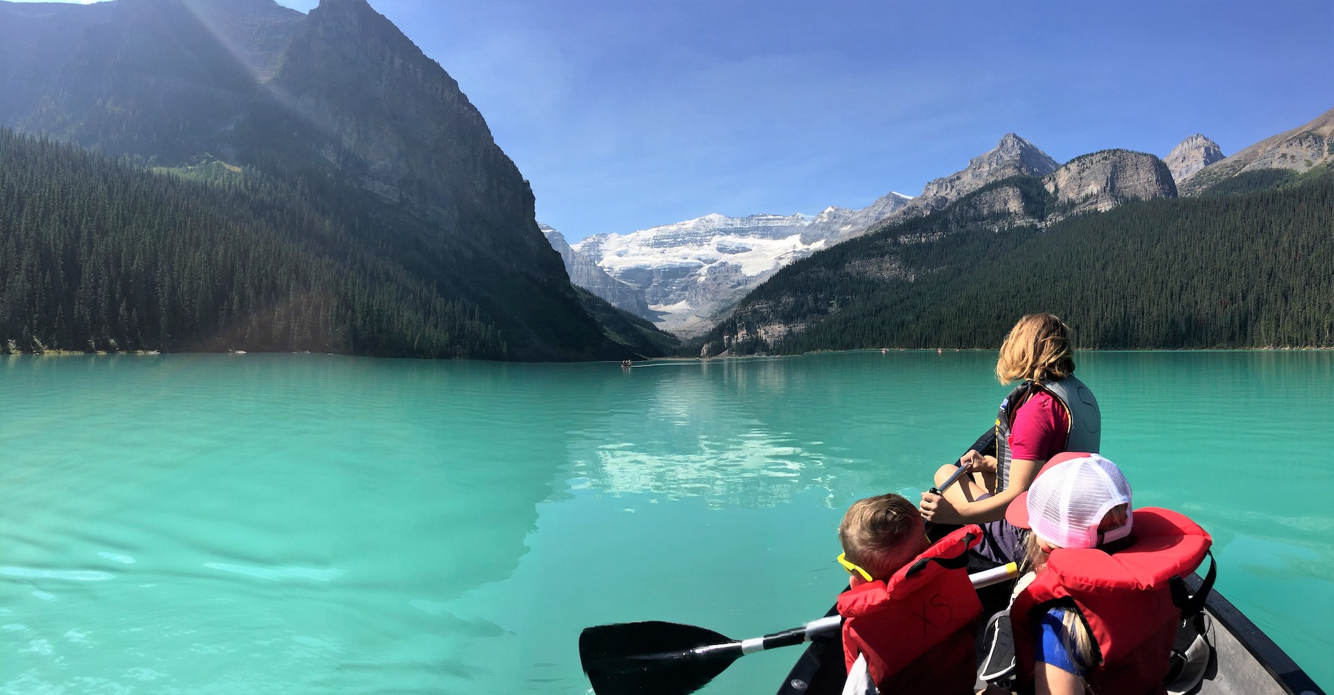
You have seen photos of the lake but they haven’t prepared you for how it feels to experience it yourself. Rounding the corner, the sight of the emerald green water and rugged peaks and glaciers hits… we’ve never seen anything so dramatically beautiful.
On the shore you’re surrounded by tourist and photographers. In a canoe in the middle of the lake you’re completely alone. Surrounded by complete beauty and silence. It was breathtaking. I’m so glad we spent the $70 and rented the canoe. It was worth every penny. Start saving that $70 now and don’t spend it on anything else. (Unless you have your own!) It looked like we were paddling in a lake filled of aqua kool-aid.
WHEN TO GO:
It is best to go and be there before 10am, beacuse the parking lot feels up extremely fast. If you arrive after 10am you might have to park down the side of the road. They eventually have to shut the road down and only let people in as others leave.
We barley made it before they closed the road off. If there is one down side of this place is that it is very crowded and parking really is INSANE. We had to park aaall the way down the road and it was TIGHT, right on a cliff.
COST
FREE – Just park and walk
Canoe Rentals: $70/ hour
There is only one boat rental on the lake and it’s operated by the Fairmont Chateau Lake Louise hotel. Standing at the hotel looking out at the lake it is located on the left hand side accessed by a pathway. Canoes are available on a first come, first serve basis. They can’t be reserved.
THINGS TO DO:
HIKING
SKIING
TRAIL RIDING
SIGHT SEEING
MOUNTAIN BIKING
SNOW TUBING AND SNOW SHOEING
CANOEING
Can I Bring My Own Canoe Or Kayak To Use At Lake Louise?
Yes, you can use your own canoe or kayak at Lake Louise or any of the lakes or rivers within Banff National Park. There’s no public boat launch at Lake Louise. You will have to carry your canoe from the government parking lot area and launch it from shore of the lake. Parks Canada offers more information on paddling in the parks.
LOCATION
It is right off the Ice Field Parkway. Just follow the signs.
It is about a 40 minute drive from Banff to Lake Louise. (80 minutes if you want the scenic route: Bow Valley route 1A.)
BACK TO:
Click here to return to our Complete Guide to Banff and Jasper National Park
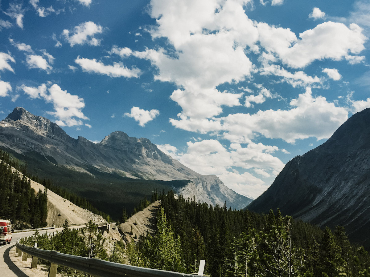
The breathtaking stretch of road between Jasper and Lake Louise serves up many of the most rewarding travel experiences in the Canadian Rockies.
Linking Lake Louise with Jasper, Alberta is one of the most beautiful journeys on the planet – the Icefields Parkway.
Unlike any other, the stretch of road from Jasper to Lake Louise known as the Icefields Parkway is dotted with more than 100 ancient glaciers, cascading waterfalls, dramatic rock spires, and emerald lakes set in sweeping valleys of thick pine and larch forests. RIGHT OFF THE SIDE OF THE ROAD. It was truly spectacular. If you go to that area you HAVE to drive it. It will blow your mind!
The abundance of wildlife in Jasper National Park and Banff National Park will have you peering around every turn. So take your time, stop for a hike to a breath-taking view point, capture that stunning photo to share with friends and enjoy a roadside picnic amidst the splendour of the Canadian Rockies pristine wilderness.
Rated as one of the top drives in the world!
LENGTH:
The Icefield Parkway is 144 miles (232km)…yes, 144 MILE stretch of highway winding along the Continental Divide through soaring rocky mountain peaks, icefields and vast sweeping valleys.
In our Itinerary we give you 2 days to drive this road. Once going up and once going down. There is still no way to do all the sites so it will always leave you wanting more. Choose your favorites, or just simply drive. It is a minimum of 3 hours drive with no stops along the way.
THINGS TO DO:
THE BEST HIKES: Ranging from short walks on wide paths to four-hour half day excursions, some of the best hikes along the Icefields Parkway are just off the highway:
MT. EDITH CAVELL
PARKER RIDGE TRAIL
BOW SUMMIT LOOKOUT
BOW GLACIER FALLS
HELEN LAKE
PLAIN OF SIZ GLACIERS
VALLEY OF THE TEN PEAKS
POINT OF INTEREST
ATHABASCA FALLS
SUNWAPTA FALLS
GLACIER SKY WALK
COLUMBIA ICEFIELD
PARKER RIDGE
BIG HILL & BIG BEND
WEEPING WALL
SASKATCHEWAN RIVER CROSSING
PEYTO LAKE AND BOW SUMMIT
BOW LAKE
VIEW WILDLIFE: Grizzly bear, Black bear, Woodland Caribou, Bighorn sheep, Mountain goats, Elk, Lynx and Bobcats, Marmots, Pika, and Ptarmigan
PHOTOGRAPHY POINTS:
MORAINE LAKE
THE COLUMBIA ICEFIELD
PEYTO LAKE
WATERFOWL LAKES
BRIDAL VEIL FALLS
PARKERS RIDGE
TANGLE FALLS
SUNWAPTA FALLS
MAPS
GALLERY
BACK TO:
Click here to return to our Complete Guide to Banff and Jasper National Park
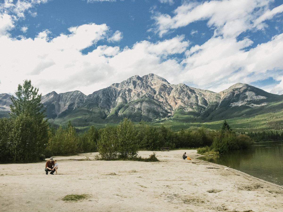
Nestled at the base of Pyramid Mountain, which overlooks the town of Jasper in Jasper National Park, Pyramid Lake is one of 20 small lakes left behind by retreating glaciers.
We felt like Pyramid Lake was a little hidden gem we stumbled upon. We were out bear watching and started to get hungry so looked for a picnic spot and found this amazing lake. It was close to our campground (20min) we went looking for a nice place to picnic and ended up swimming and spending a couple of hours here. It was just so pretty and the kids loved playing in the water and Lillian and Scott actually went out to the end and went COMPLETELY UNDER! They’re the brave souls of the family! We loved this little spot. You can again rent canoes here or you can bring your own or any fun water toy (SUP) and put in!
WEATHER:
We went to Pyramid Lake right after we left Maligne Lake Cruise. If you notice In our Maligne lake picture we’re all bundled up from the clouds and rain, and here were in our swim suits! ALL IN THE SAME DAY. Pyramid lake is about 15 minutes from the town of Jasper and 1hr 20min minutes from Maligne Lake. That’s how fast the weather can change up there. You really need to pack for all seasons. You never know when a storm will roll in and roll out!
THINGS TO DO:
Appreciate the serene beauty of the lake back dropped by the Pyramid mountain as you hike along the 2 km lakeshore trail.
Walk (wheel chair accessible) along the wooden bridge to the Pyramid lake island, and picnic at the log frame pavilion/picnic shelter.
Have a beach day at the lake (located opposite side of the lake).
Good birdwatching spot to see herons, loons & chickadee.
Spot wildlife including beaver and elk near the lake in the morning and evenings.
Watch a million stars from the Pyramid Lake Island at night (Jasper is an official Dark Sky Preserve). Join for ‘Astronomy on the Island’ program conducted by Parks Canada at the Pyramid Lake Island.
Pyramid Lake Boat Rentals: Canoes, kayaks, paddleboats, rowboats and motor boats are available for rent from the resort. $ 40 for first hour , $ 25 extra per additional hour. Paddle boat: $45.00 for one hour.
LOCATION:
JASPER, ALBERTA CANADA
Located next to Patricia Lake, Pyramid lake is ~ 5km from the 4 way junction of Pyramid Lake road & Bonhomme street. To reach the Pyramid Lake beach, turn left just before the lake and take the Pyramid lake road.
Pyramid Lake Island is accessed through a short walk from the parking lot located 1 km from the Pyramid Lake resort.
The road to the Pyramid Lake beach is closed in winter.
GPS COORDINATES:
GPS : 52.915087,-118.089945.
PYRAMID LAKE GALLERY
BACK TO:
Click here to return to our Complete Guide to Banff and Jasper National Park
View the sheer force of one of the most powerful waterfalls in the Canadian Rockies.
At 23 m (75.5 ft) in height, Athabasca Falls may not be the tallest waterfall in the Canadian Rockies but it is one of the most powerful, due to the sheer volume of water flowing into the gorge from the Athabasca River, fed by the massive Columbia Icefield.
There are a number of platforms and walkways where you can view the falls.
Located 30 km (19 mi) south of the town of Jasper, it is easily accessed from the Icefields Parkway using Highway 93A. Plenty of free parking and an easy stroll to the falls. Take the walk way down and you can view Mount Athabasca behind the falls as well and watch rafters start their journey down the river while the little ones search for all kinds of fun rocks!
Take the walk way down and you can view Mount Athabasca behind the falls as well and watch rafters start their journey down the river while the little ones search for all kinds of fun rocks!
THINGS TO DO:
Walk along the interpretive trail along the Athabasca river and learn about the Athabasca river and the water fall.
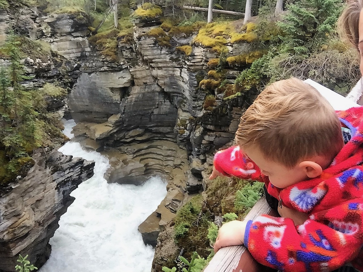
Hike along the canyon (stay on trail) and marvel at the deep canyon from various lookouts, caused by the flowing water, which still whittles away the rock floor few millimeters each year.
Cross the concrete bridge , climb down the stairs to the bottom of the falls to see the canyon caused by earlier erosion and appreciate the might of flowing water.
Notice the tiny plants, mosses, litchens, trees that have found a foothold in the narrow crevices of the Canyon.
Try to spot the dark grey bird called Canyon sprite as it zooms down into the gorge.
LENGTH:
From the parking lot, the Athabasca falls hike is only about 1 mile. It’s really just a nice nature walk and site to see.
How long to see it? Half an hour to an hour and a half depending on interest.
TRAIL DETAILS:
The trail is paved and there are concrete bridges over the gorge. Walk along the interpretive trail which explains the science of the water colour, how the canyon was formed and flaura & fauna in the area. Cross the bridge and walk down the stairs to see the gorge caused by the river.
LOCATION:
JASPER, ALBERTA CANADA
Located 30 km (19 mi) south of the town of Jasper, it is easily accessed from the Icefields Parkway using Highway 93A. Plenty of free parking and an easy stroll to the falls.
GPS COORDINATES:
GPS coordinates : 52.666142,-117.884313
ATHABASCA FALLS GALLERY
BACK TO:
Click here to return to our Complete Guide to Banff and Jasper National Park
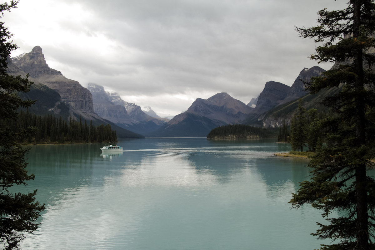
There are those places that take your breath away and you just stand in awe thinking…. Am I really here right now? Maligne Lake is one of those places.
Maligne Lake is the longest lake in the Canadian Rocky Mountains at 22.5 km’s and the second largest glacier fed lake in the world. It’s home to Spirit Island, a picture perfect spot that’s featured on calendars around the world.
The true attraction of Spirit Island is the backdrop: a ring of impressive peaks and glaciers circling the south end of Maligne Lake, and the deep turquoise water color not present at the North end of the lake. A short path forms a loop from the docks to viewing points overlooking Spirit Island. To preserve the area in its natural state, walking onto the island is not allowed.
The only down side of the tour is that you only get 15 minutes on shore by Spirit Island. The plus side is that it’s not over crowded and feels like you have it to yourself. A new boat arrives every 15 minutes. However, you could upgrade to a premium cruise and get 30 minutes and extra time on the Isand I believe..
Maligne Lake was Scotts favorite adventure we did in our 8 days in Jasper and Banff.
WHY WE CHOSE THIS TOUR
In this area Brewster Tours rules this area and have for 125 years, and they seriously know that they’re doing. And believe it or not, it’s very affordable. For the boat tour you get to choose between Lake Minnewanka in Banff or Lake Maligne in Jasper. After lots of research and reviews I chose Jasper. The reason is because there was no way to see Spirit Island any other way than by boat, unless you wanted to row your canoe for 8 hours. (Which Scott and I have added that to our Bucket List) Details for booking listed below.
You get the choice of riding inside the heated boat or step out with the wind on your face. Both are great. The boat has a lot of windows so both ways you get to see the majestic view around you. Inside the guide retells Maligne’s history and explains its geology, wildlife, and weather.
The lake is surrounded by the Queen Elizabeth mountain range on one side and the Maligne range on the other.
COST
We purchased the JASPER ULTIMATE EXPLORER COMBO PACKAGE from Brewster Pursuit which included: Maligne Lake Cruise, Ice Glacier Explorer, Sky Walk, and the Banff Gondola
The Total cost for all 4 excursions was $552 for all 4 of us. Which came to $184 /per adult and $92 per kid, however if you divide that by 4 excursions then it comes to $46 per person per excursion.
ALA CARTE BOAT CRUISE PRICING:
Rates for adults are $65 and for children $33 (ages 4 and under are free)
There’s a boat tour geared towards photographers with longer time at Spirit Island. The total cruise is 2.5 hours instead of 1.5 hours. A local professional photographer comes along to assist in getting photos. They run on selected days only from early July to mid-September. The cost is $145 per person.
LENGTH
Spirit Island is located 14km’s down the lake from where the boat launch is located.
Classic Cruise: 1.5 hours total. 15 minutes on Spirit Island.
Premium Cruise: 2 hours total. 30 minutes on Spirit Island.
LOCATION
The drive is just under 50 km’s from Jasper, it takes approximately an hour to reach Maligne Lake. For the return trip and taking in a pre-reserved boat cruise you would want to allow for a minimum of 4 hours. Longer if you want to make any sightseeing stops along the way, do any hiking or have a meal at the cafe at the lake.
Allow yourself time to leisurely drive Maligne Lake road stopping at places like Medicine Lake along the way. It is such a beautiful area you can spend all day exploring.
DIRECTIONS
From the town of Jasper head north on Yellowhead Hwy 16 and watch for signs for Maligne Road where you will turn right and follow the road for approximately one hour until it ends at Maligne Lake.
The best time to visit Maligne Lake is in the morning before the first cruise. The light is typically better. The crowds are much less populated. And, you will improve your chances of seeing wildlife.
OPEN:
The boat tours usually start towards the end of May or early June depending on the weather conditions and when the lake thaws. They run into the first week of October.
Boats leave on the hour from 10 am to 5pm from early July to early September. During the early and later part of the season the last boat of the day leaves at either 3pm or 4pm. See their site for the current schedule.
BOOK YOUR EXCURSIONS:
The first thing I did when I got to town was go and purchase my excursion package. You can also do this online ahead of time as well. The pricing is very reasonable.
We recommend doing the JASPER ULTIMATE EXPLORER COMBO PACKAGE that includes Maligne Lake Tour, Columbia Icefield Glacier Discovery that includes the Icefield Skywalk, and the Banff Gondola. They were all amazing.
If your time is limited in Jasper you may want to make other areas your priority such as walking or hiking in Maligne Canyon and driving the Icefields Parkway. We would not recommend rushing out to Maligne Lake just to take the boat cruise and come back again. It’s an hour drive in each direction from town. Options for other lakes closer to town are Annette or Edith Lakes. It’s a short drive to the pretty setting of Pyramid Lake. It also has it’s own version of an island with a wooden boardwalk to access it.
Getting To Spirit Island On Your Own
The only other option for getting to Spirit Island is by kayak or canoe. Rentals are available through Curly’s boathouse located just a bit further down the shoreline from where the boat tours leave. From the boathouse to Spirit Island is approximately 14 km’s one way. It wouldn’t be something to take on unless you are a well experienced paddler. The lake is subject to strong winds and rough conditions. It can be accomplished in a day, but if you run into foul weather or rough conditions you may have to be prepared to wait along the shoreline hoping it passes. It can be anywhere from 3 to 6 hours to reach the island depending on the conditions. There is a campsite te at Fisherman’s Bay at the 13km mark just before Spirit Island and another at the 21.5km mark at Coronet Creek.
BACK TO:
Click here to return to our Complete Guide to Banff and Jasper National Park
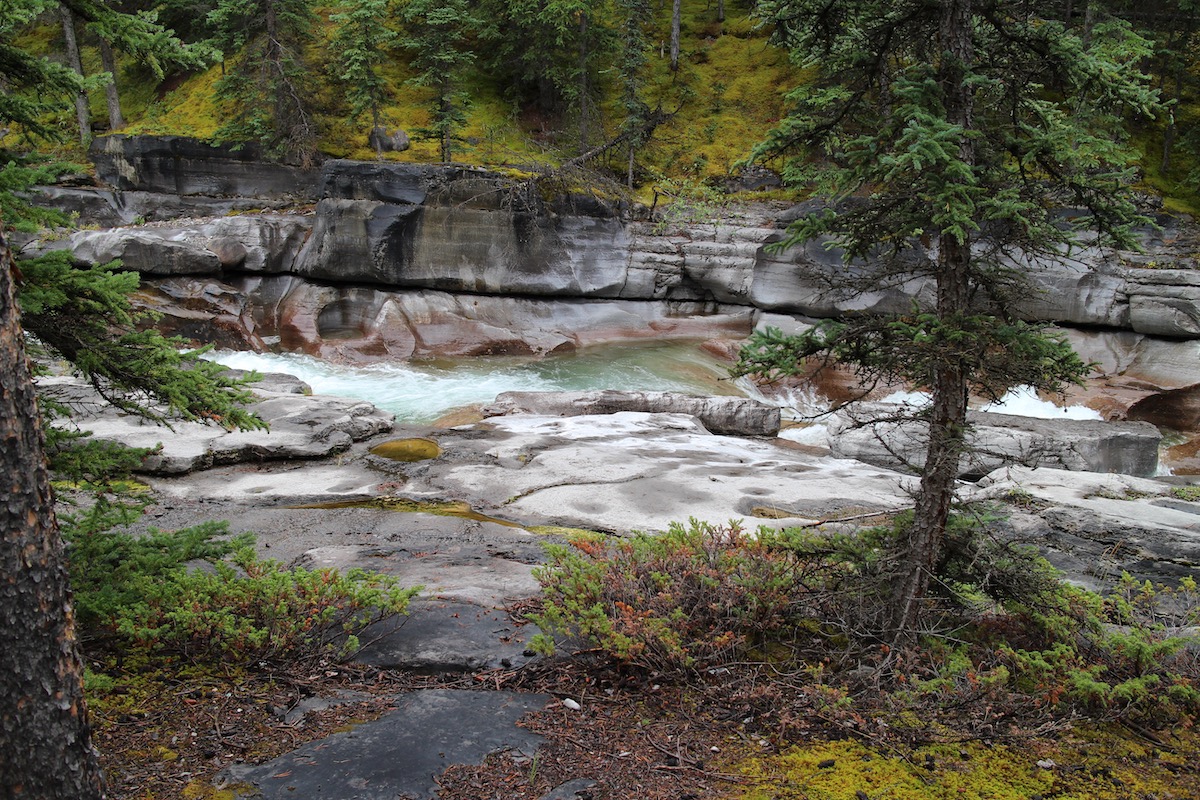
Maligne Canyon is the deepest canyon in the Rockies! It looked and felt like we were in the Pacific Northwest surrounded by mist and covered in moss.
Maligne river, that originates at Maligne lake flows underground from Medicine lake, until it reaches Maligne Canyon. At the canyon, carved into the Palliser Formation — a layer of limestone deposited in a shallow tropical sea by lime-secreting plankton, the underground streams join force, to become the mighty flowing water that still whittles the canyon away. Maligne canyon has a depth of more more than of 50 m at certain points.
It was so neat to be able to see. It’s a great “hike” for kids. All the walks are paved and really nice. It was overcast and raining while we were there so the walks were a little slick. The farther you go in the steeper the walks get, it was even more beautiful and green in person.
LENGTH:
Distance 3.7 km (from the Sixth Bridge one way) 2.3miles
Allocate 1 to 3 hours.
TRAIL DETAILS & GPS COORDINATES:
Depending on your time and agility, you can choose from a variety of hiking options. There are three ways to access Maligne Canyon.
From the main parking lot near the tea house and the Hi Maligne Canyon Lodge, which gives you access to the first bridge. GPS : 52.920728,-117.999004
From fifth bridge. GPS: 52.9214565, -118.0168955
The sixth bridge. If you start from here, you will be doing the full loop. GPS: 52.933431,-118.030225
The spectacular canyon views are near the first and second bridge. There are trails on either side of the canyon. The tallest waterfall is near the second bridge. If you are short on time, cross the first bridge, walk along the canyon ridge and then cross back at the second bridge and turn back.
If you want to see the Maligne Canyon at its best, go till fifth bridge (at least till fourth if short on time). 4.4 km return with 100 m elevation gain.
The advantage of hiking up from fifth or sixth bridge is that you will be able to avoid the crowds in high season.The distance from the fifth bridge to sixth bridge is ~1.6 km. This is a shared trail (bike + horseback riding)
The trail head to 2.1 km flower loop and the 15.5 km(one way ) Overlander trail starts at the sixth bridge.
THINGS TO DO:
Hike down the canyon from the parking lot near the tea house and observe the natural rock formations and large dry potholes.
Walk along the rim of the canyon to the subsequent bridges, reading the interpretive displays: Enjoy a lesson in geology.
Marvel at the deep canyon, the water falls and the power of the churning, swirling river that created it, from the first and second bridges. Notice the water that disappeared at the Medicine Lake flowing into the Maligne Canyon through the underground cave system from the fourth bridge.
Observe the mosses, the lichens on the canyon walls . Try to spot American dipper as it swoops down to feed on underwater insects, check for Black swift and raven nests on the canyon walls.
Observe the river becoming wider and the river gaining in water volume by the time you reach the sixth bridge (due to more water from underground lakes), near the junction of Maligne and Athabasca river.
Enjoy Aurora-gazing / stargazing at Maligne Canyon during Jasper Dark Sky Festival – 2016 Dates: October 8, 15 (moon viewing), 19, 22, 29 | 10:30 PM
LOCATION:
Maligne Canyon sits at the gateway to Jasper’s Maligne Valley, just minutes from Jasper and home to some of region’s most breathtaking scenery and iconic adventures. Named for its haunting atmosphere, Maligne Canyon is the deepest canyon in the park, dropping to a depth of more than 50m at some points. Six bridges built across the canyon allow hikers of all abilities to explore this incredible natural landmark.
DIRECTIONS:
To get to the Maligne Canyon Trailhead, follow Highway 16 towards Edmonton; go 1.8 km past the east Jasper exit to the Maligne Road. On the Maligne lake road go 2.1 km and then turn left at the Sixth Bridge sign. If you want to shorten the hike a little you can turn left at the fifth bridge(at 2.9 km), or just go straight to the Maligne Canyon itself(at 6.1 km). *The hike from the sixth bridge would be considered a must from our point of view.
Maligne Adventures : 3 hours – Rate/ Price:$65.00 +GST; Youth (7-14): $32.50 + GST. GST extra. Not recommended for children under 7.
Sun dog tours : 3 hours – Adult: $65.00 & Child (6 -12): $29.00 + GST. Not recommended for children under 6.
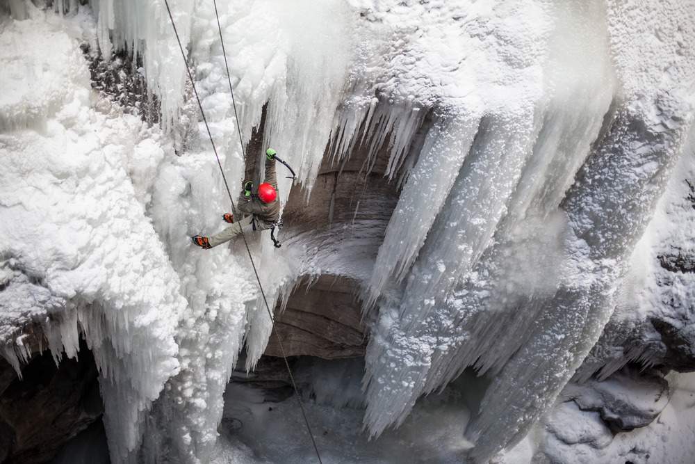
Maligne Canyon Ice Walk on Your Own (DIY)
If planning to do the Ice walk in Maligne Canyon on your own, get waterproof snow boots and fit it with ice cleats/crampons/micro spikes. Plan for two hours. Please make sure that you are in a group. It is good to do it on a guided tour.
Park at the parking lot near the tea house and walk till the fifth bridge, enjoying the frozen waterfalls and ice sculptures on the canyon rim as you peer down the canyon from the rim. The winter hiking trail for Maligne canyon ice walk starts near the fifth bridge. Follow the frozen river, and walk up the river into the canyon.
Walk on the frozen river bed enjoying the astonishing natural ice sculptures, and frozen water falls. Watch the ice climbers making their way up. Turn back once you reach the third bridge. You can continue further, but it is safer to turn back at this point especially if you are alone.
Another option is to park near the fifth bridge, and enter the canyon from here for the Maligne canyon ice walk.
BACK TO:
Click here to return to our Complete Guide to Banff and Jasper National Park


